
This ride turned out to be as epic as I had hoped it would. We used GMRS for comms, so almost everyone was in comms, adding to the fun. I don't know how many times I was laughing in my helmet from the wise cracks. The group was a perfect size with two support vehicles to keep the beer cold, and our loads a little lighter. Plus, they were great people. I would travel again with them, anytime. Thanks Heather and Andrew, you guys are Awesome!!
Day 1 and 2
We met up at Mesa Marin gas station not far from Rancheria Rd. Rancheria is a dirt track that starts right at Bakersfield and heads up to Portuguese pass. It was hot starting out through the golden grass and oak lands, but we were excited just to get going. This road heads up through old California rancher country, passing closed up home steads, as it climbs up to the forest. First we encountered the Oaks, and then the shabby Grey Pines that line the lower forest edge of the San Joaquin Valley. The temps steadily dropped and then dropped suddenly to the cool 70's, when we hit the forest line.

Arnie lost bolt while crossing a cattle stopper and we stopped at a nice spot while he searched for it and tightened up his one remaining bolt. We took a break at Portuguese Pass. I tried to use the outhouse, not a good idea. A poo bomb must have went off in that place. Not kidding! After Portuguese pass the road turned to a single lane paved road, that interchanged with dirt. This whole first day was incredible riding. Higher and higher into the cedars and firs. This was the big end of Summer weekend, but there were not many people, only a few camping here and there.

Forest Rd 23S16 was closed in a section, so to get around that closure, we took a road with some barely used tracks. There was brush over hanging over the trails, which added some unwanted character to our two support vehicles (sorry Heather and Andy). As is turned out, my route actually dropped us out right near the closure, and didn't get us around it at all. I think at this point some folks may have started to question my guide skills. Oh well! it was fantastic adventure riding. Arnie (Afry), Josh and Chris went ahead to scout out the closure, with Chris returning to report that is was passable. Good news, as this turned out to be a dream single lane road that we had all to ourselves. However, it was a bit scary for the support vehicles getting through the section. Arnie and Josh kept riding ahead and for a minute or so we had comms, but then we lost them.

We decided to continue on, and find a camping spot along the route. That way, we could eventually meet up. It wasn't much of a camping spot just really a wide spot in the road on Windy Gap Trail. We found bear scat on the trail, adding to a little worry. No bears visited us that first night, but I went to sleep a little concerned for Arnie and Josh. I kept wondering if they had found a spot to camp. In the morning, the Nissan had a drained battery. So, our start was delayed while a set of jumper cables were found. Supplied by John, a friendly Forest Service Ranger, who pretty much gave us his life story along with a jump.

Arnie and Josh came up on the radios, the ranger completed the story of his prior career in Kansas and off we went. Windy Gap Trail turned out to be a blast. It went on and on, up and down, through the forest, until we came across our first Sequoias on the trail. Some of course were massive and very picturesque being that we weren't on a paved road or in any park.

Dakota climbed around an enormous Sequoia, that was just off the road. What an impressive tree!! Something about these trees make the soul ache. That kind of lonely yearning for something far off and better, more pure and what should have been.
 The standard text book narrative says that the Giant Sequoia (Sequoiadendron giganteum) once had a much broader range and due to changing climate conditions shrank back to its current grove locations. This narrative has been repeated over and over since the 19th century. John Muir noted problems with this narrative in his book On the post-glacial history of the Sequoia Gigantea. Muir noted that on the edge of the groves the trees are the youngest and at the center of the groves are the most majestic and noble specimens. More current research searching for pollen evidence in soil samples has also came up empty. 'The Giant Sequoia pollen distribution apparently is locational to the current groves. The Giant Sequoia is extremely rote and bug resistant due to the tannin in the wood fibers and takes eons to fully decompose. So where are the falling trees outside the groves? For that matter shouldn't there be more fallen ancient trees inside the groves as well? You would think that the forest would be littered with fallen giants like a gargantuan game of pick up sticks, but all you see are a few fallen botanical generals. Maybe fire is the answer to the riddle?
 The fact is there is no evidence at all the Giant Sequoia (Sequoiadendron giganteum) ever existed outside its current location and further more it seems to be expanding out not shrinking in. Its as if the genesis of the giants was recent (as in thousands of years not millions)", in the heart of the groves and now its just starting its eon long march ever outward. That's a satisfying thought.The sequoia is also not a slow growing species, it actually is one of the fastest, if you count the sheer bulk in wood fibers it packs on every year. A sequoia a few centuries old can pack on the equivalent wood fiber of a normal size mature tree every year.Think of the massive amounts of carbon each tree pulls from the air and stores up.

 We left the grove behind us, and we started passing little vacation cabins, as we got closer to Camp Nelson. I wondered what kind of people were lucky enough to live in a place like this. Camp Nelson started as a sort of cowboy camp. It is where ranchers and cowboys would stop off, while driving cattle from the high meadows to the valleys. John Nelson planted an apple orchard and in the 1890's built a Hotel for the visitors. The Governor of California was one of the first paying customers, of the hotel, in 1892.
  We rolled up to the small business strip. It was decorated with old classic American advertisements. While Arnie checked the hardware store for his missing bolt, we checked out the small store. Then, we got lunch in Mo's Diner. This is one of those small Americana type places where you're waited on by the owner. They have standard diner fare, and a good beer selection. The owner gave Heather some stickers, making my first sticker of the trip. The bikes fueled up at the gas pump, which was hidden behind the store, while the 4X4's decided to wait until Springville, for cheaper prices.


 Continuing on we soon descended back into the lowland September heat taking pavement back in the oak woodlands. We followed the east fork of the Tule river through a canyon, with periodic pull outs lined with cars, where weekenders were swimming in the river pools below. We came to a T in the road and took the left into Spring ville There we got fuel and cold drinks. The route now followed under maintained, twisty roads, that weaved through cattle county with virtually no one else on the road. Then, the dirt road, we were supposed to turn off on, turned out to be gated. We took a break and discussed what to do next. We broke out the paper maps, and decided the only option was to continue on the tarmac to Sequoia National Park.
 We made it to the park, paid our money and headed up the road, to the first campground. This campground was supposed to have sites available. Arnie headed up the pack. He got there first, and radioed back that it to was full. While we mustered up the bikes at a picnic area, we decided to head back to a campground we had passed on the way. It was only about 20 minutes from the park gate. As it turned out, we camped outside the park, but the campground had showers. Yeah!! And, tents on grass is always nice!!

Day 2 Video
Day 3 and 4
Arnie headed out early, to scope out a hardware store he saw the day before, still in search of his lost foot peg bolt. This time he was successful. The rest of us continued to pack and enjoy breakfast and morning coffee. As Arnie rolled up, it was time to head out. One problem Chris's keys were no where to be found. A panicky Chris tore through his stuff, while the rest of us looked around in the grass pretending to be helpful. He finally found them, allowing the rest of us to start the teasing, which we'd held wisely back while he was still looking for the keys. Finally, we started out with a stop off at the Sequoia National Park visitor center.We purchased tickets to Crystal Cave (and of course a sticker). We missed the 130 tour and picked up tickets for the 200 tour. We had some time to kill so we decided to go check out the big trees and have some lunch.


After we ate, we headed down to Crystal Cave on a paved steep foot path passing waterfalls on the way. Fletch took a fall on the slick rocks,but was alright . The cave was a nice 50 degrees inside and felt refreshing, compared to the heat outside. It was a fun side excursion and educational for Dakota, but took a big chunk from the day. Getting to the cave required a small 1/2 mile hike with about 500 ft of elevation drop meaning we had to hike back up. This wasn't ideal in riding boots. Our guide told us that Crystal Cave is only one of 200 caves located in the park. The rest of the caves are closed to the public. If you do this ride I would recommend cutting out the cave, and adding the Kings Canyon Rt 180 dead end ride to it instead.


 We said goodbye to Bakersfield Bill (Portabill), who had to start a new job the next day. He represented the Vstrom community well, showing the bike is fully capable of fire road exploring, under the right rider. We headed back up the road for the cave turn off, and came to a stopped vehicle. Curious as to what he was watching, we scanned the vegetation along the road. To Dakotas excitement it was a bear!! We did a quick turn around and Dakota, standing on the passenger foot pegs, took some pictures. Dakota tried to get a shot of the bears face', from the back of the bike, but his timing was off. Every time he took a shot the bear had his head down feeding on berries. My amateur photographer's frustration grew trying to get the perfect picture. Still a huge thrill for a 11 year old for sure!! I can see why visitors miss read bears, because this guy had the friendliest face so content to just munch away in his berry patch.
 Back on the generals hwy, we took a side road to tour more big trees,stop at a gift shop and headed to Kings Canyon. It was long, amazing, paved road through the mountains. That night, we camped at Azalea Campground near the Kings Canyon Visitor Center and Village. We got a little toasty around the camp fire, until a polite Ranger shut down the fun and it was off to bed.
We got a gentle reminder to use the bear boxes, when we awoke to some sealed food in my panniers ripped open and scattered around my bike. A couple deer came through camp, which of course excited Dakota. He got some shots of them with his camera.

Day 3 was going to be a long day packed with lots of dirt trails and mountain twisties. We needed to get within shooting distance of Yosemite before camp, and we had lots of mileage to cover. It started to sprinkle a bit, as a summer thunderhead passed over, It felt great. But I kept thinking of the dirt. I knew what was coming, and didn't want to descend in mud. The weather past and we headed down the road. We pulled off onto a long section of dirt, that descended out of the mountains and down to a river valley. Periodically, we past what was left of old cattle settlements and passed cows standing in and grazing along the road. The more elevation we lost the hotter it got. Fletcher had a little scare when his 1200GS ADV went off the trail misguided by a rut, he couldn't get out of. Luckily it was recoverable, and just suffered some small external character dings.


As we neared the bottom, we came across an old gold mine. Dakota explored a bit, before a concerned dad had him get out. On my USGS map it's just labeled as "claim", with no other clues. I wonder what the story is here did they get what they were digging for? Or was it a failure?

After exploring the mine, we continued to drop elevation until we dropped to 1,100 ft and it was around 100 degrees. We were hot and dirty, but luckily came to the Kings river which was nice and cool. Kick stands went down and we changed to swim trucks.Man, oh man, did it feel good! Wow, how awesome! It was cool and refreshing. Whether, fat,old and/or pasty white, we did not improve the scenery ;)


 Enjoying the river and hopefully cutting down on our road funk we heard a truck coming down the road. Crap all our bikes and the support vehicles were right were we left them in the middle of the stinking road. We climbed out of the river negotiated the rocks with our bare feet and started pulling bikes out of the way. A couple guys got out and approached us. They turned out to be some good natured good ole boy type locals. One had a story to tell about killing the biggest snake he's ever seen with his 45cal pistol the other fresh from a tour in Afghanistan in the Army.
 After the chat we cleaned the dirt off our feet the best we could and slipped our riding cloths on over our swimming trucks and headed out. We crossed a old bridge full of past character rounded a corner and was immediately hit with a wall of hot air. It was over 100 degrees in the canyon and the heat was radiating off the rock walls. I could not wait to get back to the high country!! We continued on headed up the river until we passed the small hamlet of Balch Camp. Then we headed up Black Rock Rd an incredible gorgeous ride on a narrow shelf road high above the canyon of the North Fork of the Kings River. We didn't see a single vehicle headed up the gorge which seriously was a good thing.
The segment above Granite Gorge is particularly impressive. About half of the road is paved but it still had the element of excitement because it edges along the canyon walls with sheer drop-offs without railings with only one narrow lane and absolutely no forgiveness. Views were fabulous but because of the danger we don't have that many pics. We crossed several bridges that spanned spaces in the rock. I think it was a bit more exciting for our British expat manned support vehicle which could not ride the inside track like we could. England just does not have places like this or 45 cal wielding snake killers either for that matter.

 From here we traveled on dirt and pavement headed for a late lunch at Shaver Lake. We would have liked to camp here but we needed to cover more miles.We had a dirt segment planned for this section but when we pulled off the pavement it looked a little more technical than we should attempt this late in the afternoon and loaded down with gear. So we continued on slabbing it to the community of Shaver Lake. Shaver lake was a nice mountain community the kind of place i could spend days at with my family. I plan to go back maybe next summer and give it more attention.

The guys ordered Pizza and beer and Heather and her hubby Wayne headed
 for home in there Jeep. Now down to one support Vehicle with Andrew and Rockie. After Shaver Lake we dropped back on to a dirt road to continue for many miles on a dream dirt road labeled Old Railroad Grade Rd. Old Rail Road Grade is whats left of the The San Joaquin & Eastern Railroad (SJ&E) that was built in 1912 to cover over 56 miles of rough terrain. They used only hand labor and what were called Fresno Scrapers pulled by mules, working 7 days a week, 10 hours a day. The railroad was completed in a record 157 days, to create John Eastwood's 1893 vision of a massive hydroelectric system, now known as Southern California Edison's Big Creek Hydroelectric Project. The tracks were pulled in 1933 leaving the the road that was so enjoyable to ride. It was kind of dusty so we spaced it out. I went my usually slower pace of 20 to 25 Arnie and Josh rolled ahead at a faster clip. We got to a nice stopping point by Stevenson Creek and took a break while Dakota disappeared exploring the creek. I got a little alarmed when we saw a sign that the creek was used as a spill way for Shaver Reservoir and they periodically released water. Yicks. The yelling started Dakota!! Dakota!!. Soon he was back and it was time to get moving again.
 Then time for diner we were getting gear out of the panniers to make diner when Dakota got another scare a camper walked by with a German Shepard and when Dakota turned to look at it his headlamp shone in the dogs face and it lunged at him barking savagely. The owner strained against the lease but the dog pulled so hard that the owner fell and tumbled still holding the leash. Wow i had my Gerber tool in my hand as my only weapon if the dog broke loose but as the situation calmed i felt my grip on the tool and knew what i almost had to do. Remarkably we had cell phone service i don't know why because there wasn't anything like settlements or civilization anywhere close to us. Talking to his mom right then was blessing turns out his mom was a a prayer meeting praying for our safety right when this excitement was going down.
The nice thing was we were well positioned to roll into Yosemite by lunch the next day!!
Day 5 and 6

We turned off onto dirt and took multiple dirt tracks with two stream crossings toward the Hwy 41. Rockie our trip photographer filmed the crossings but everyone stayed up right. The temps where cool in the mountains that morning and felt nice.
We popped out on pavement just a few miles from the park entrance and headed to a gas stop where i continued my quest for stickers for my panniers (the real reason for the whole trip) 8-). We said good bye to Chris who took off to meet up with his hunting Dog being trained near Bodie. We decided to meet up in Bodie at high noon the next day.


 Now headed to the valley and a free meal on our minds we soon saw what makes people keep coming back to this park. The beautify is so incredible the whole place looks photo shopped. The creator wanted to say something pretty special here. We are told that Yosemite is the result of massive glaciers advancing and retreating through the valley over tens of thousands of years. That interpretative narrative is just not satisfying. Its just to mechanical for such a inspiring and amazing place. Its kind of like saying the Sistine Chapel frescoes were a result of pigments and brushes whipping on plaster during the middle ages. That narrative leaves out the artist and does not attempt to understand the message or intent. Yosemite is greater than a glacier carved valley with out purpose or meaning.

After getting some pics from a road side view point we headed through valley with the Nissan hanging behind for more pictures. We passed another father son riding team the boy about Dakotas age decked out in black leather. We rolled up to the lodge lodge everyone hungry for lunch. The valley was much hotter than the high country we'd been riding through all morning. Dakota got a treat as a young fawn and its mother were browsing on leaves totally unconcerned with the tourists snapping pictures all around them.


 We arrived to late for breakfast but Fletch always the gentleman treated us to some lunch in the cafeteria. We decided over lunch to find somewhere to camp up on Tioga pass. We departed from our last support vehicle and packed our bikes down with the remaining gear they were hauling for us. Thanks Andy and SOCAL Froaders we appreciate the support!! The valley is smaller that i thought it would be and went through it way to quickly. The route up Tioga pass took us through multiple tunnels and past recent forest fire clearings but eventually we got to awesome views of granite and lakes.


We stopped at a view point to take some pictures and take it all in Dakota jetted up a granite slab with the excuse of getting pictures from a better location. I watched him climb the rock knowing he was in his element. A boy in paradise on an epic adventure!!
 |
| Dakota coming down off the mountain |


We rolled into camp at Tuolumne Meadows Campground. The young ranger girl at the check in gave us the campground for free because they didn't want to charge us a vehicle pass for every bike. She did warn us about a bear that comes into camp everyday. Some would meet the bear later that night.
Note: Put backpacks with half eaten cookies in the supplied bear box.


Some got a good nights sleep other not so much. We headed down the road taking frequent stops to take in the beauty and majesty. Our modern language and specifically my vocabulary just isn't sufficient to describe a place like Yosemite


We dropped out of the mountains pretty quickly in fact a little to quickly. An elevation sign gave away why we were still at 8000Ft!! We stopped for gas and snacks at Lee Vining near Mono Lake. Mono Lake is an ancient natural saline soda lake that rests in Mono Basin at 6300 ft. It formed in the mono basin because no outlet exists to the ocean. Salts from the surrounding mountains dissolve in the streams and build up in the lake. Ancient lake shore lines have been found above Lee Vining with Ice Age levels above 900 ft.

We took a left on 395 headed north and turned off on the 167 and then off on the to take the south entry dirt road into Bodie. Kind of fun but also a lot of wash board. Still riding down a dirt road with my 11 boy on the back to an old western ghost town was awesome. I knew he was going to love it!! Last year he was in a musical play here in Pine Valley on the gold rush and and has his own gold pan that he's used searching for pay dirt in the back yard:)


 We crested a hill and could see Bodie down below awesome. I could imagine being on a horse with a bustling Bodie below which my Winchester loaded and ready. We meet Chris in the parking lot and took a couple hours just walking around and taking it all in. If you've never been it was well worth the ride out. Bodie was a thriving wild west boom town fueled by the lust for gold. Shootouts, stage coach robberies and brothels all were common right here in Bodie. The place is amazing you can just imagine a Clint Eastwood character walking the streets. The population dwindled in the 1920's and a fire in 1933 destroyed much of the structures but maintained a post office and a few residents until 1942.


Chris left us at Bodie he cut a foot in the King River and it was starting to bug him. The rest of the Motley Crew headed south on the 395 and took a scenic ride down the June Lake loop.


Devils Post Pile was next on the tour and we rolled through mammoth past the gondolas still running in summer. We rolled up on the park post and paid our 10 dollars and headed down the windy single lane road. Roger decided to split from the group leaving just 4 bikes in the group. A delivery truck was headed up and the car in front of me did an immediate panic stop, A close call and a reminder we are back riding alone cars not accustomed to mountain roads.


Devils post pile was created by a lava flow that cooled uniformly and cracked into beautifully straight hexagonal columns (Dakota and I actually spotted another less dramatic example the next day headed south on the 395). During the ice age or glaciation period, ice ground down and polished the top of the columns. The park literature says the glacial period ended 15,000 years ago but can that really be correct? Look at the polished tops of the columns. Would the rock really maintain its polish for that long? The book of Job says, “From whose womb comes the ice? And the frost of heaven, who gives it birth? The waters harden like stone, and the surface of the deep is frozen.” Could the Ice Age have happened thousands rather than 10 of thousands of years ago? Was Job penned during the Glaciation period that formed Yosemite? Why would an author living in the middle east write about the ocean freezing? Could that polish on the top of Devils Post Pile really still be smooth after 15,000 winters and summers, hail storms rain, freezing, thawing etc?

Roger bailed in Mammoth and the rest of us camped out down at Devils Post Pile. Fletcher talked to the Ranger and found out that just down the road was a "resort". Resort being to grand a title for Red Meadows Pack Station but they had a general store, 5 dollar showers and a small diner. Eureka!! We camped at Red Meadows camp ground just around the corner from the pack station. A good meal after a shower priceless!! The first shower in 3 days and a good meal.


Day 7 and 8
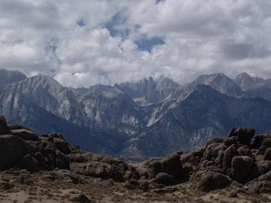
Arnie and Josh started the long trek home on the 395 just leaving Dakota, Me and Fletch. We rolled through Movie Flat loop in Lone Pine for some more dirt and some amazing views. Over 700 films were made here including the first episode of the Lone Ranger.


Fletcher treated us to lunch in Lone Pine and he started the long trek home. Dakota and I visited the museum and watched a short film on movies produced here. Recommend if you do the loop make sure you stop in the museum and watch the film.
After the short stop we headed south and made it to our final camp at Big Bear before heading home the next day via Idyllwild.


Pics from the ride.
Link to Map and GPS files of route.
Epic is the word! Well done, your son is one of a few privileged ones out there. Thanks for the post and all the photos, simply lovely!
ReplyDeleteSerfie sa
Decals sometime calls identification decals are easy to apply, they are just right value and is usually easily eliminated with no damage your objective areas. They cover the large range of visual styles available so select a style that meets your own identification perspective and start activities as your liveable place of work.
ReplyDeleteVery interesting subject , thanks for posting . ac repair yorba linda
ReplyDelete